Geographic Information System/Merge
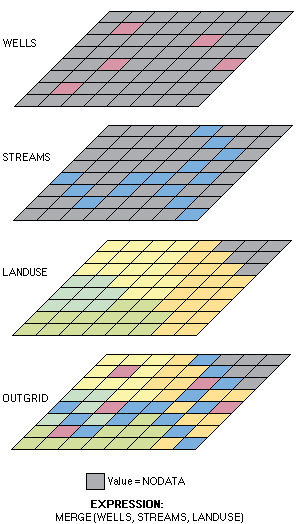
Merge is a Geoprocessing tool that is very commonly used in ArcGis. If you need to use merge, that means you are taking multiple datasets that have the same data type, and putting it together to make a new output dataset. This tool lets you use multiple sources to combine them, rather than having multiple datasets, it makes it more organized. For example, rather than having to go back and forth between three maps, you can merge all of those datasets into one, so you can still see all of the same information from the three maps, but merged onto one single map. Merging simply makes your product easier and more organized.
For example: If I have a map of Dunn County, and I want to add a separate map that shows specific boundaries in Dunn County, instead of having two separate maps to go back and forth on, I can merge the maps on the same page and have them all on the same layer.