File:Moors murders map.jpg

Size of this preview: 800 × 494 pixels. Other resolutions: 320 × 198 pixels | 640 × 395 pixels | 1,024 × 633 pixels | 1,280 × 791 pixels | 3,250 × 2,008 pixels.
Original file (3,250 × 2,008 pixels, file size: 354 KB, MIME type: image/jpeg)
| This is a file from the Wikimedia Commons. The description on its description page there is shown below.
Commons is a freely licensed media file repository. You can help. |
Summary
| Camera location | | View this and other nearby images on: OpenStreetMap |
|---|
| Description |
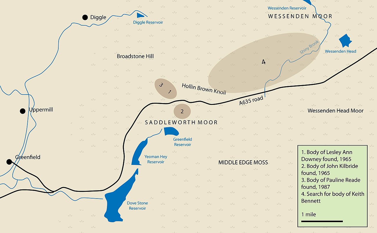
English: A general map of the area in which the burial of three of the victims of the Moors Murderers took place. |
| Date | |
| Source | Own work. Based on a map reproduced between pages 96 and 97 of Topping, P (1989), Topping: The Autobiography of the Police Chief in the Moors Murder Case, Angus & Robertson, isbn 0-207-16480-0 |
| Author | Parrot of Doom |
| Other versions | Derivative works of this file: Moors murders (rus).jpg |

|
This incident map image could be re-created using vector graphics as an SVG file. This has several advantages; see Commons:Media for cleanup for more information. If an SVG form of this image is available, please upload it and afterwards replace this template with
{{vector version available|new image name}}.
It is recommended to name the SVG file “Moors murders map.svg”—then the template Vector version available (or Vva) does not need the new image name parameter. |


.jpg)
Licensing
| I, the copyright holder of this work, release this work into the public domain. This applies worldwide. In some countries this may not be legally possible; if so: I grant anyone the right to use this work for any purpose, without any conditions, unless such conditions are required by law. |
File history
Click on a date/time to view the file as it appeared at that time.
| Date/Time | Thumbnail | Dimensions | User | Comment | |
|---|---|---|---|---|---|
| current | 18:43, 3 October 2009 | | 3,250 × 2,008 (354 KB) | Parrot of Doom | Fix infobox to avoid reeds |
| 13:34, 2 October 2009 |  | 3,250 × 2,008 (351 KB) | Parrot of Doom | Rotate burial sites (Reade's further behind Downey) | |
| 12:58, 2 October 2009 |  | 3,250 × 2,008 (351 KB) | Parrot of Doom | clipped reeds | |
| 12:27, 2 October 2009 |  | 3,250 × 2,008 (354 KB) | Parrot of Doom | Fix Kilbride date | |
| 12:17, 2 October 2009 |  | 3,250 × 2,008 (354 KB) | Parrot of Doom | Much more detail | |
| 11:55, 2 October 2009 |  | 3,250 × 2,008 (289 KB) | Parrot of Doom | More detail | |
| 21:43, 1 October 2009 |  | 3,250 × 2,008 (255 KB) | Parrot of Doom | Diggle placemark | |
| 21:41, 1 October 2009 |  | 3,250 × 2,008 (250 KB) | Parrot of Doom | {{Information |Description={{en|1=A general map of the area in which the burial of three of the victims of the Moors Murderers took place.}} |Source={{own}} |Author=Parrot of Doom |Date=1 October 2009 |Permission= |other_versions= |
File usage
The following page uses this file:
Global file usage
The following other wikis use this file:
- Usage on da.wikipedia.org
- Usage on en.wikipedia.org
- Usage on fr.wikipedia.org
- Usage on it.wikipedia.org
- Usage on ja.wikipedia.org
- Usage on ko.wikipedia.org
- Usage on pl.wikipedia.org