File:Housing Development.pdf

Size of this JPG preview of this PDF file: 414 × 599 pixels. Other resolutions: 166 × 240 pixels | 331 × 480 pixels | 679 × 983 pixels.
Original file (679 × 983 pixels, file size: 701 KB, MIME type: application/pdf)
| This is a file from the Wikimedia Commons. The description on its description page there is shown below.
Commons is a freely licensed media file repository. You can help. |
Summary
| Category | Information |
|---|---|
| Project Name | Housing Development |
| University Name | Carleton University, B. Architecture |
| Year | 2012 |
| Student Name | Natalie Petricca |
| Short Description | This housing development was designed to reinvigorate the space behind the Notre Dame Cathedral in Ottawa that is currently a parking lot. An emphasis was put on one’s journey through the site, concealing and revealing the church along the path and providing spaces of pause in the form of gardens and seating. The idea of solid and void within the site was also brought down to the micro scale in the construction detail by incorporating voids to bring in natural light and hanging the cladding apart from the structure. |
| Location of Project | Sussex Street and St. Patrick Street |
| Link to The Hub Google Map | https://maps.google.ca/maps/ms?ie=UTF8&hl=en&oe=UTF8&msa=0&msid=217510189257377561113.0004d619400b6c022f1be |
| Description | |
| Date | |
| Source | Own work |
| Author | Jaclyn Squizzato |
| Camera location | | View this and other nearby images on: OpenStreetMap |
|---|
Licensing
I, the copyright holder of this work, hereby publish it under the following license:
This file is licensed under the Creative Commons Attribution-Share Alike 3.0 Unported license.
- You are free:
- to share – to copy, distribute and transmit the work
- to remix – to adapt the work
- Under the following conditions:
- attribution – You must give appropriate credit, provide a link to the license, and indicate if changes were made. You may do so in any reasonable manner, but not in any way that suggests the licensor endorses you or your use.
- share alike – If you remix, transform, or build upon the material, you must distribute your contributions under the same or compatible license as the original.
File history
Click on a date/time to view the file as it appeared at that time.
| Date/Time | Thumbnail | Dimensions | User | Comment | |
|---|---|---|---|---|---|
| current | 13:39, 14 March 2013 | 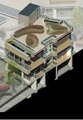 | 679 × 983 (701 KB) | Jaclynsquizzato | User created page with UploadWizard |
File usage
The following page uses this file: