File:Folded Old Red Sandstone at St Annes Head - geograph.org.uk - 629204.jpg
No higher resolution available.
Folded_Old_Red_Sandstone_at_St_Annes_Head_-_geograph.org.uk_-_629204.jpg (640 × 468 pixels, file size: 448 KB, MIME type: image/jpeg)
| This is a file from the Wikimedia Commons. The description on its description page there is shown below.
Commons is a freely licensed media file repository. You can help. |
Summary
| Description |
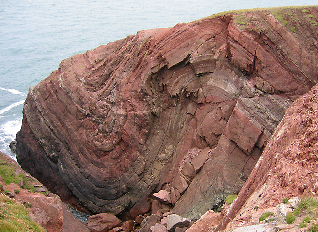
English: Folded Old Red Sandstone rock formation — at St Annes Head in Pembrokeshire, Wales.
|
||
| Date | |||
| Source | From geograph.org.uk | ||
| Author | Rodney Harris | ||
| Permission (Reusing this file) |
This file is licensed under the Creative Commons Attribution-Share Alike 2.0 Generic license. Attribution: Rodney Harris
|
||
| Attribution (required by the license) | Rodney Harris / Folded Old Red Sandstone at St Annes Head / | ||

| Camera location | | View this and other nearby images on: OpenStreetMap |
|---|
_heading:315.00&language=en)
| Object location | | View this and other nearby images on: OpenStreetMap |
|---|
_heading:315.00&language=en)
File history
Click on a date/time to view the file as it appeared at that time.
| Date/Time | Thumbnail | Dimensions | User | Comment | |
|---|---|---|---|---|---|
| current | 05:50, 7 February 2011 | | 640 × 468 (448 KB) | GeographBot | == {{int:filedesc}} == {{Information |description={{en|1=Folded Old Red Sandstone at St Annes Head The sedimentary Old Red Sandstone, laid down in the Devonian period, is intensely folded by collision of tectonic plates during the Carboniferous period, kn |
File usage
The following page uses this file:
Global file usage
The following other wikis use this file:
- Usage on en.wikipedia.org
- Usage on en.wiktionary.org
- Usage on fr.wikipedia.org
- Usage on it.wikipedia.org
- Usage on nl.wikipedia.org
- Usage on uk.wikipedia.org
- Usage on vi.wikipedia.org
- Usage on www.wikidata.org
- Usage on zh.wikipedia.org