File:Eastern White Pine Pavilion Design.pdf

Size of this JPG preview of this PDF file: 800 × 571 pixels. Other resolutions: 320 × 229 pixels | 640 × 457 pixels | 1,050 × 750 pixels.
Original file (1,050 × 750 pixels, file size: 1.58 MB, MIME type: application/pdf)
| This is a file from the Wikimedia Commons. The description on its description page there is shown below.
Commons is a freely licensed media file repository. You can help. |
Summary
| Category | Information |
|---|---|
| Project Name | Rest Stop |
| University Name | Carleton University, Bachelor Architecture |
| Year | 2011-2012 |
| Student Name | Natalie Petricca |
| Short Description | ‘Rest Stop’ is sited in a secluded Eastern White Pine forest in Rovaniemi, Finland. It is customary in Finnish architecture to extend the threshold, and this was incorporated into the design, as the whole pavilion becomes a threshold, where the division between outside and inside is blurred. The use of the 3” x 3” posts in every aspect of the design mimic the powerful vertical members of the forest. The members are more dense along the south and west faces as this is the direction from which the prevailing winds blow, especially in the winter. They become more spread out and shorter along the north and east faces to capture the low morning light. The seating was specially designed to fit an average sized person and the incline of the back encourages one to gaze upwards to the phenomena of the Northern Lights in the winter months. The seating was placed with the backs towards the southwest so that in the winter when the wind blows from that direction one can sit and watch the Northern Lights and be comfortable and warm. During the winter, reindeer pelts could be placed over the chairs to make them even more comfortable. The shading provided by the horizontal elements creates a play of shadows on the seating and on the people sitting in them. |
| Location of Project | Rovaniemi, Finland |
| Link to The Hub Google Map | https://maps.google.ca/maps/ms?ie=UTF8&hl=en&oe=UTF8&msa=0&msid=217510189257377561113.0004d619400b6c022f1be |
| Description | |
| Date | |
| Source | Own work |
| Author | Jaclyn Squizzato |
| Camera location | | View this and other nearby images on: OpenStreetMap |
|---|
Licensing
I, the copyright holder of this work, hereby publish it under the following license:
This file is licensed under the Creative Commons Attribution-Share Alike 3.0 Unported license.
- You are free:
- to share – to copy, distribute and transmit the work
- to remix – to adapt the work
- Under the following conditions:
- attribution – You must give appropriate credit, provide a link to the license, and indicate if changes were made. You may do so in any reasonable manner, but not in any way that suggests the licensor endorses you or your use.
- share alike – If you remix, transform, or build upon the material, you must distribute your contributions under the same or compatible license as the original.
File history
Click on a date/time to view the file as it appeared at that time.
| Date/Time | Thumbnail | Dimensions | User | Comment | |
|---|---|---|---|---|---|
| current | 16:05, 13 March 2013 | 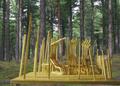 | 1,050 × 750 (1.58 MB) | Jaclynsquizzato | User created page with UploadWizard |
File usage
The following page uses this file: