File:Upsala Glacier, Argentina.jpg
Original file (4,288 × 2,848 pixels, file size: 4.91 MB, MIME type: image/jpeg)
| This is a file from the Wikimedia Commons. The description on its description page there is shown below.
Commons is a freely licensed media file repository. You can help. |
Summary
| Description |
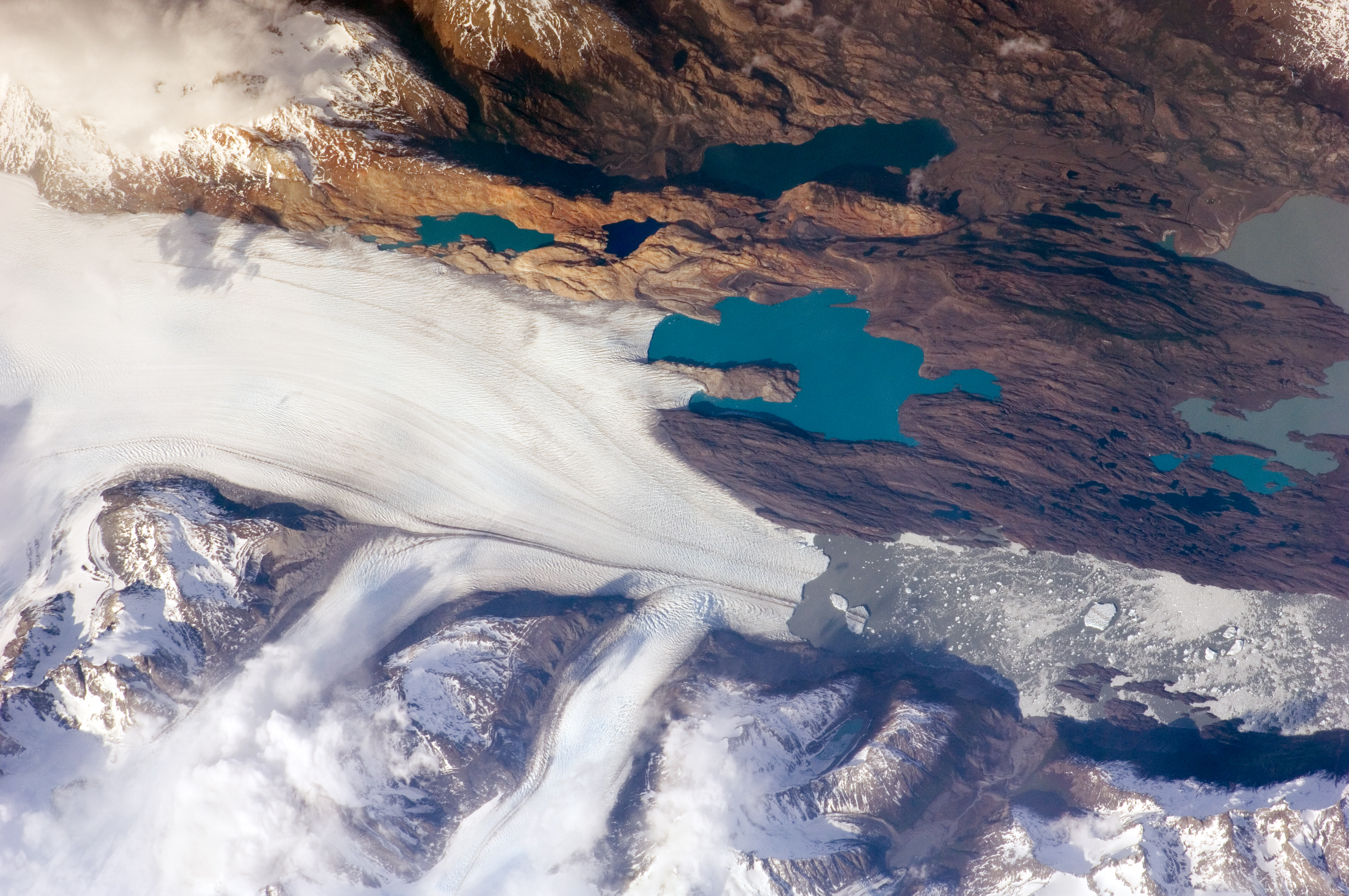
English: The Southern Patagonian Icefield of Argentina and Chile is the southern remnant of the Patagonia Ice Sheet that covered the southern Andes Mountains during the last ice age. This detailed astronaut photograph illustrates the terminus of one of the ice-field’s many spectacular glaciers—Upsala Glacier, located on the eastern side of the ice-field.
This image was taken during spring in the Southern Hemisphere, and icebergs were calving from the glacier terminus into the waters of Lago Argentino (Lake Argentina, image right). Two icebergs are especially interesting because they retain fragments of the moraine (rock debris) that forms a dark line along the upper surface of the glacier. The inclusion of the moraine illustrates how land-based rocks and sediment may wind up in ocean sediments far from shore. Moraines are formed from rock and soil debris that accumulate along the front and sides of a flowing glacier. The glacier is like a bulldozer that pushes soil and rock in front of it, leaving debris on either side. When two glaciers merge (image centre), moraines along their edges can join to form a medial moraine that is drawn out along the upper surface of the new glacier. |
| Date | Taken on 25 October 2009 |
| Source | NASA Earth Observatory |
| Author |
This image was taken by the NASA Expedition 21 crew
|
| Camera location | | View this and other nearby images on: OpenStreetMap |
|---|
|
This image or video was catalogued by Johnson Space Center of the United States National Aeronautics and Space Administration (NASA) under Photo ID: ISS021-E-15243. This tag does not indicate the copyright status of the attached work. A normal copyright tag is still required. See Commons:Licensing. Other languages:
|
Licensing
This file is in the public domain in the United States because it was created by the Image Science & Analysis Laboratory, of the NASA Johnson Space Center. NASA copyright policy states that "NASA material is not protected by copyright unless noted". (NASA media use guidelines or Conditions of Use of Astronaut Photographs).
Photo source: ISS021-E-15243.
|
| Annotations | This image is annotated: View the annotations at Commons |
File history
Click on a date/time to view the file as it appeared at that time.
| Date/Time | Thumbnail | Dimensions | User | Comment | |
|---|---|---|---|---|---|
| current | 17:13, 3 February 2017 | | 4,288 × 2,848 (4.91 MB) | Ras67 | new rendered in high quality from NASA's raw image data (with 5500 K) |
| 09:32, 9 June 2010 |  | 3,072 × 2,032 (5.45 MB) | Originalwana | higher res | |
| 11:01, 17 November 2009 |  | 1,440 × 960 (942 KB) | Originalwana | {{Information |Description={{en|1=The Southern Patagonian Icefield of Argentina and Chile is the southern remnant of the Patagonia Ice Sheet that covered the southern Andes Mountains during the last ice age. This detailed |
File usage
The following page uses this file:
Global file usage
The following other wikis use this file:
- Usage on ast.wikipedia.org
- Usage on be.wikipedia.org
- Usage on bn.wikibooks.org
- Usage on bs.wikipedia.org
- Usage on cs.wikipedia.org
- Usage on de.wikipedia.org
- Usage on en.wikipedia.org
- Usage on eo.wikipedia.org
- Usage on es.wikipedia.org
- Usage on fa.wikibooks.org
- Usage on fr.wikipedia.org
- Usage on he.wikipedia.org
- Usage on hr.wikipedia.org
- Usage on hy.wikibooks.org
- Usage on it.wikibooks.org
- Usage on it.wikiversity.org
- Usage on ko.wikipedia.org
- Usage on pl.wikipedia.org
- Usage on ru.wikipedia.org
- Usage on sh.wikipedia.org
- Usage on sl.wikipedia.org
- Usage on sv.wikipedia.org
- Usage on ta.wikipedia.org
- Usage on uk.wikipedia.org