File:Trachyandesite at Clermont-Ferrand in France.jpg

Size of this preview: 800 × 600 pixels. Other resolutions: 320 × 240 pixels | 640 × 480 pixels | 1,024 × 768 pixels | 1,280 × 960 pixels | 2,560 × 1,920 pixels.
Original file (2,560 × 1,920 pixels, file size: 3.68 MB, MIME type: image/jpeg)
| This is a file from the Wikimedia Commons. The description on its description page there is shown below.
Commons is a freely licensed media file repository. You can help. |
Summary
| Description |
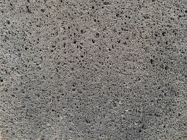
English: A cut block of trachyandesite lava, used as a type of building stone known locally as "La pierre de Volvic" ("Volvic Stone"), forming part of the walls of Notre-Dame-de-l'Assomption Cathedral in Clermont-Ferrand, France. This rock originally formed part of a trachyandesite lava flow that was erupted 11,000 years ago from Puy de la Nugère volcano during a strombolian-style eruption. This trachyandesite is frost-resistant and has a low coefficient of expansion, making it an attractive material for construction. This view is about 10 centimetres across. (Some parts of this description are based on a translation of some sentences of the French Wikipedia article http://fr.wikipedia.org/wiki/Pierre_de_Volvic which is Copyright CC-BY-SA-3.0). |
| Date | |
| Source | http://www.geodiversite.net/media1208 |
| Author | zarmel http://www.geodiversite.net/auteur2 |
| Camera location | | View this and other nearby images on: OpenStreetMap |
|---|
Licensing
This file is licensed under the Creative Commons Attribution-Share Alike 3.0 Unported license.
- You are free:
- to share – to copy, distribute and transmit the work
- to remix – to adapt the work
- Under the following conditions:
- attribution – You must give appropriate credit, provide a link to the license, and indicate if changes were made. You may do so in any reasonable manner, but not in any way that suggests the licensor endorses you or your use.
- share alike – If you remix, transform, or build upon the material, you must distribute your contributions under the same or compatible license as the original.
This file, which was originally posted to
geodiversite.net, was reviewed on 17 February 2014 by reviewer Bobamnertiopsis, who confirmed that it was available there under the stated license on that date.
|
File history
Click on a date/time to view the file as it appeared at that time.
| Date/Time | Thumbnail | Dimensions | User | Comment | |
|---|---|---|---|---|---|
| current | 14:50, 12 February 2014 | | 2,560 × 1,920 (3.68 MB) | GeoWriter | User created page with UploadWizard |
File usage
The following 2 pages use this file:
Global file usage
The following other wikis use this file:
- Usage on ca.wikipedia.org
- Usage on en.wikipedia.org
- Usage on pt.wikipedia.org
- Usage on zh.wikipedia.org