File:Pinatubo6.png

Pinatubo6.png (468 × 371 pixels, file size: 168 KB, MIME type: image/png)
Summary edit
| Description |
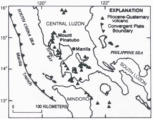
This picture is a map of where Mt.Pinatubo is in the Philippines. |
|---|---|
| Source |
This image appears to be a shaded modification of Figure 1 from an article entitled, "Eruptive History of Mount Pinatubo" at url=http://pubs.usgs.gov/pinatubo/newhall/. Figure 1 itself is url=http://pubs.usgs.gov/pinatubo/newhall/fig1.gif and is likely Public Domain as a USGS map made by USGS employee Christopher G. Newhall. |
| Date |
June 11, 1999 |
| Author |
original is by Christopher G. Newhall, shading source is unknown. |
| Permission (Reusing this file) |
Fair Use
|
Licensing edit

This work is copyrighted. The individual who uploaded this work and first used it in an article, as well as subsequent persons who place it into articles, asserts that this qualifies as fair use of the material under United States copyright law.
This template must be accompanied by a {{Non-free media rationale}} justifying the assertion of fair use.
Note: The kinds of things that are considered acceptable for fair use on Wikiversity is significantly less than what is legally permitted. Please consult the Wikimedia Foundation Fair Use Policy to see if this content is permitted on Wikiversity under these further restrictions. Familiarize yourself with the Wikiversity Exemption Doctrine Policy before using this template.
File history
Click on a date/time to view the file as it appeared at that time.
| Date/Time | Thumbnail | Dimensions | User | Comment | |
|---|---|---|---|---|---|
| current | 05:42, 2 March 2012 | | 468 × 371 (168 KB) | JustinFong (discuss | contribs) | Map of where Mt.Pinatubo is |
You cannot overwrite this file.
File usage
The following page uses this file: