File:PIA04256 Map of Martian Silicon at Mid-Latitudes.jpg

Original file (2,065 × 929 pixels, file size: 170 KB, MIME type: image/jpeg)
| This is a file from the Wikimedia Commons. The description on its description page there is shown below.
Commons is a freely licensed media file repository. You can help. |
Summary
| Description |
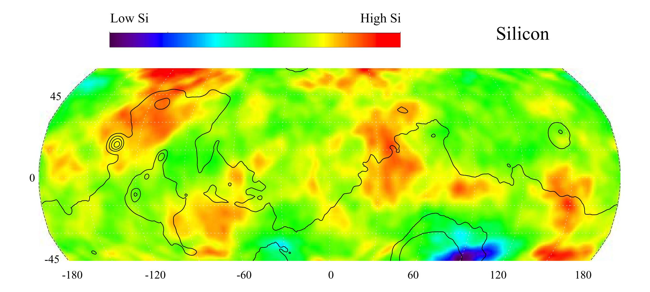
English: This gamma ray spectrometer map of the mid-latitude region of Mars is based on gamma-rays from the element silicon. Silicon is one of the most abundant elements on the surface of both Mars and Earth (second only to oxygen). The most extensive region of highest silicon content, shown in red, is located in the high latitudes north of Tharsis (centered near 45 degrees latitude, -120 degrees longitude). The area of lowest silicon content, shown in blue, lies just to the east of the Hellas Basin (-45 degrees latitude, 90 degrees longitude). Contours of constant surface elevation are also shown. The long continuous contour line running from east to west marks the approximate separation of the younger lowlands in the north from the older highlands in the south.
NASA's Jet Propulsion Laboratory manages the 2001 Mars Odyssey mission for NASA's Office of Space Science, Washington, D.C. The gamma ray spectrometer was provided by the University of Arizona, Tucson. Lockheed Martin Astronautics, Denver, Colo., is the prime contractor for the project, and developed and built the orbiter. Mission operations are conducted jointly from Lockheed Martin and from JPL, a division of the California Institute of Technology in Pasadena. |
| Date | (published) |
| Source | Catalog page · Full-res (JPEG · TIFF) |
| Author | NASA/JPL/University of Arizona |
| Other versions |
|

This image or video was catalogued by Jet Propulsion Laboratory of the United States National Aeronautics and Space Administration (NASA) under Photo ID: PIA04256. This tag does not indicate the copyright status of the attached work. A normal copyright tag is still required. See Commons:Licensing. Other languages:
|
| This media is a product of the 2001 Mars Odyssey mission Credit and attribution belongs to the Gamma Ray Spectrometer (GRS) team, NASA/JPL/University of Arizona |
Licensing
| This file is in the public domain in the United States because it was solely created by NASA. NASA copyright policy states that "NASA material is not protected by copyright unless noted". (See Template:PD-USGov, NASA copyright policy page or JPL Image Use Policy.) | ||
 |
Warnings:
|
Original upload log
- 2010-09-15 03:17 Schaffman 2065×929× (173637 bytes) {{Information |Description = Silicon Map of Mars |Source = JPL Photojournal http://photojournal.jpl.nasa.gov/catalog/PIA04256 |Date = ~~~~~ |Author = University of Arizona |Permission = JPL Public Use Policy |other_v
File history
Click on a date/time to view the file as it appeared at that time.
| Date/Time | Thumbnail | Dimensions | User | Comment | |
|---|---|---|---|---|---|
| current | 19:49, 21 September 2011 | | 2,065 × 929 (170 KB) | File Upload Bot (Magnus Manske) | {{BotMoveToCommons|en.wikipedia|year={{subst:CURRENTYEAR}}|month={{subst:CURRENTMONTHNAME}}|day={{subst:CURRENTDAY}}}} {{Information |Description={{en|Silicon Map of Mars}} |Source=Transferred from [http://en.wikipedia.org en.wikipedia]; transferred to C |
File usage
The following 5 pages use this file:
Global file usage
The following other wikis use this file:
- Usage on ca.wikipedia.org
- Usage on en.wikipedia.org
- Usage on es.wikipedia.org
- Usage on no.wikipedia.org
- Usage on sv.wikipedia.org
- Usage on uk.wikipedia.org
- Usage on zh.wikipedia.org