File:Magnetic North Pole Positions.svg

Original file (SVG file, nominally 567 × 581 pixels, file size: 470 KB)
| This is a file from the Wikimedia Commons. The description on its description page there is shown below.
Commons is a freely licensed media file repository. You can help. |
Summary
| Description |
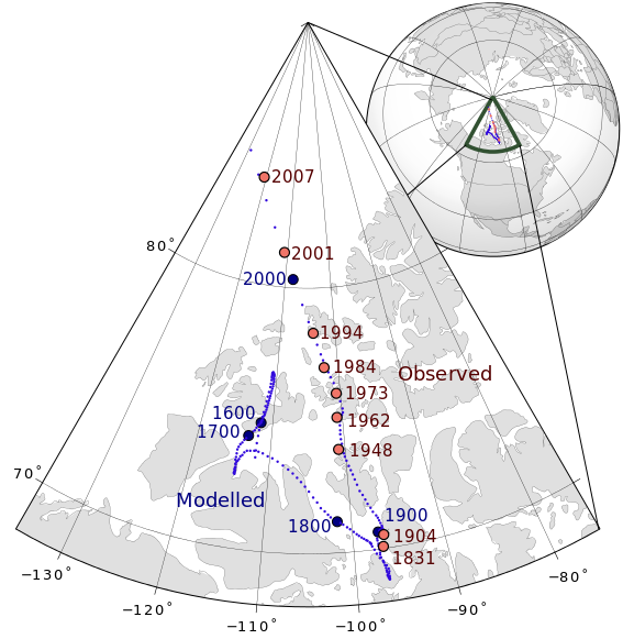
English: Magnetic north pole positions of the Earth.
Poles shown are dip poles, defined as positions where the direction of the magnetic field is vertical. Red circles mark magnetic north pole positions as determined by direct observation, blue circles mark positions modelled using the GUFM model (1590–1980) and the IGRF model (1980–2010) in 2 year increments. |
||
| Date | |||
| Source |
Own work |
||
| Author | Tentotwo | ||
| SVG development |
|

| Year | Latitude | Longitude | Observer |
|---|---|---|---|
| 1831 | 70° 05' N | 96° 47' W | James Ross |
| 1904 | 70° 31' N | 96° 34' W | Amundsen |
| 1948 | 73° 54' N | 100° 54' W | Serson, Clark |
| 1962 | 75° 06' N | 100° 48' W | Loomer, Dawson |
| 1973 | 76° 00' N | 100° 36' W | Niblett, Charboneau |
| 1984 | 77° 00' N | 102° 18' W | Newitt, Niblett |
| 1994 | 78° 18' N | 104° 00' W | Newitt, Barton |
| 2001 | 81° 18' N | 110° 48' W | Newitt, Mandea, McKee |
| 2007 | 83.95° N | 120.72° W | Newitt, Chulliat, Orgeval |
GMT Source Code
GMT is a Generic Mapping Tool.
<source lang="bash">
- !/bin/sh
GMT psxy -m -JE-105/90/15c -R-140/-70/65/90 -Ba10g10 --POLAR_CAP=none --BASEMAP_TYPE=plain --BASEMAP_AXES=WeS 50m_land.gmt -K -G224/224/224 > aeqd.ps GMT psxy -m -JE-105/90/15c -R-140/-70/65/90 50m_coastline.gmt -O -K -W100/100/100 >> aeqd.ps GMT psxy -m -JE-105/90/15c -R-140/-70/65/90 50m_borders.gmt -O -K -W100/100/100 >> aeqd.ps grep "2.000$\|4.000$\|6.000$\|8.000$\|0.000$" NP.xy | GMT psxy -m -JE-105/90/15c -R-140/-70/65/90 -O -K -Sc0.05c -G50/10/220 >> aeqd.ps grep "00.000$" NP.xy | GMT psxy -m -JE-105/90/15c -R-140/-70/65/90 -O -K -Sc0.5c -Gred >> aeqd.ps GMT psxy -m -JE-105/90/15c -R-140/-70/65/90 observed_north_magnetic_poles.txt -O -K -Sc0.25c -G240/117/104 -Wthick,0/0/0>> aeqd.ps GMT pstext -JE-105/90/15c -R-140/-70/65/90 -G0/0/0 -Dj0.15c/0.05c observed_north_magnetic_poles.txt -O -K >> aeqd.ps
GMT psxy -m -JG-105/75/6.5c -X9c -Y9c -Rg -Ba30g30 --POLAR_CAP=none 110m_land.gmt -O -K -G224/224/224 >> aeqd.ps GMT psxy -m -JG-105/75/6.5c -Rg 110m_coastline.gmt -O -K -W100/100/100 >> aeqd.ps GMT psxy -m -JG-105/75/6.5c -Rg 110m_borders.gmt -O -K -W100/100/100 >> aeqd.ps GMT psxy -JG-105/75/6.5c -Rg -Wfat,50/81/50 -L -Am -O -K << EOF >> aeqd.ps -140.0 65.0 -140.0 90.0 -70.0 65.0 EOF grep "2.000$\|4.000$\|6.000$\|8.000$\|0.000$" NP.xy | GMT psxy -m -JG-105/75/6.5c -Rg -O -K -Sc0.03c -G50/10/220 >> aeqd.ps GMT psxy -m -JG-105/75/6.5c -Rg observed_north_magnetic_poles.txt -O -Sc0.07c -G240/117/104 >> aeqd.ps gv aeqd.ps -orientation=landscape -resize }} }}
Licensing
- You are free:
- to share – to copy, distribute and transmit the work
- to remix – to adapt the work
- Under the following conditions:
- attribution – You must give appropriate credit, provide a link to the license, and indicate if changes were made. You may do so in any reasonable manner, but not in any way that suggests the licensor endorses you or your use.
- share alike – If you remix, transform, or build upon the material, you must distribute your contributions under the same or compatible license as the original.
File history
Click on a date/time to view the file as it appeared at that time.
| Date/Time | Thumbnail | Dimensions | User | Comment | |
|---|---|---|---|---|---|
| current | 01:57, 11 August 2013 | | 567 × 581 (470 KB) | Cavit | Added 2007 observed position from Newitt et al., Location of the North Magnetic Pole in April 2007, Earth Planets Space, 61, 703–710, 2009, http://www.terrapub.co.jp/journals/EPS/pdf/2009/6106/61060703.pdf |
| 14:09, 25 January 2012 |  | 567 × 581 (468 KB) | Tentotwo | Corrected latitude labels | |
| 13:56, 25 January 2012 |  | 567 × 581 (468 KB) | Tentotwo | Fixed missing labels | |
| 13:34, 25 January 2012 |  | 567 × 581 (470 KB) | Tentotwo | Reduced font size | |
| 12:57, 25 January 2012 |  | 567 × 581 (469 KB) | Tentotwo | Corrected font for grid labels | |
| 12:55, 25 January 2012 |  | 567 × 581 (469 KB) | Tentotwo | Smaller extent for wedge map | |
| 13:44, 23 January 2012 |  | 592 × 597 (562 KB) | Tentotwo | Corrected font for grid labels | |
| 13:42, 23 January 2012 |  | 592 × 597 (562 KB) | Tentotwo | Made labels slightly smaller | |
| 13:14, 23 January 2012 |  | 592 × 597 (558 KB) | Tentotwo | Corrected SVG code | |
| 12:24, 23 January 2012 |  | 592 × 597 (558 KB) | Tentotwo | Corrected page geometry |
File usage
The following page uses this file:
Global file usage
The following other wikis use this file:
- Usage on az.wikipedia.org
- Usage on de.wikipedia.org
- Usage on en.wikipedia.org
- Usage on es.wikipedia.org
- Usage on is.wikipedia.org
- Usage on ja.wikipedia.org
- Usage on uk.wikipedia.org