File:Dharavi Slum.tif

Size of this JPG preview of this TIF file: 444 × 599 pixels. Other resolutions: 178 × 240 pixels | 540 × 729 pixels.
Original file (540 × 729 pixels, file size: 747 KB, MIME type: image/tiff)
| This is a file from the Wikimedia Commons. The description on its description page there is shown below.
Commons is a freely licensed media file repository. You can help. |
Summary
| Category | Information |
|---|---|
| Project Name | Dharavi Slum |
| University Name | Ryerson University B. Architecture |
| Year | 2011 |
| Student Name | Warren Borg |
| Short Description | The theme of this thesis was "Architecture in a World of Conflict." Our instructions were to engage the issues relating to conflict and propose an architectural response. My conflict was Dharavi vs. "The Developer." By exploring both the realities and potential of those living in slums, provisions can be made to create a new approach to slum [re]-development. The concept was designed to become the cornerstone of future development models. By arguing the economic influence of slum dwellers, cities would eventually take notice. |
| Location of Project | Mumbai, India |
| Link to The Hub Google Map | https://maps.google.ca/maps/ms?ie=UTF8&hl=en&oe=UTF8&msa=0&msid=217510189257377561113.0004d619400b6c022f1be |
| Description | |
| Date | |
| Source | Own work |
| Author | Vanessahaddock |
| Camera location | | View this and other nearby images on: OpenStreetMap |
|---|
Licensing
I, the copyright holder of this work, hereby publish it under the following license:
This file is licensed under the Creative Commons Attribution-Share Alike 3.0 Unported license.
- You are free:
- to share – to copy, distribute and transmit the work
- to remix – to adapt the work
- Under the following conditions:
- attribution – You must give appropriate credit, provide a link to the license, and indicate if changes were made. You may do so in any reasonable manner, but not in any way that suggests the licensor endorses you or your use.
- share alike – If you remix, transform, or build upon the material, you must distribute your contributions under the same or compatible license as the original.
File history
Click on a date/time to view the file as it appeared at that time.
| Date/Time | Thumbnail | Dimensions | User | Comment | |
|---|---|---|---|---|---|
| current | 14:58, 14 March 2013 | 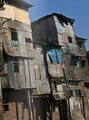 | 540 × 729 (747 KB) | Vhaddock | User created page with UploadWizard |
File usage
The following page uses this file: