File:Cryosphere Fuller Projection.png

Original file (2,703 × 1,079 pixels, file size: 1.03 MB, MIME type: image/png)
| This is a file from the Wikimedia Commons. The description on its description page there is shown below.
Commons is a freely licensed media file repository. You can help. |
Summary
| Description |
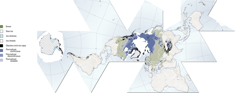
(Cryosphere) English: Author, Hugo Ahlenius, UNEP/GRID-Arendal. Full graphic, including sources, referencing etc are available here: http://maps.grida.no/go/graphic/cryosphere
.Image donated by author, no restrictions on use. Notes: Snow cover extent for Northern Hemisphere is represented by the 1966-2005 February average, for Southern Hemisphere by the 1987-2003 August average. Sea ice extent for Northern Hemisphere is represented by the 1979-2003 March average, for Southern Hemisphere by the 1979-2002 September average. Permafrost data for mountain areas and for the Southern Hemisphere are not represented in this map, neither are river and lake ice. Data sources: Armstrong, R.L. and Brodzik, M.J. (2005). Northern Hemisphere EASE-Grid weekly snow cover and sea ice extent version 3. (Digital media). National Snow and Ice Data Center, Boulder Armstrong, R.L., Brodzik, M.J., Knowles, K. and Savoie, M. (2005). Global monthly EASE-Grid snow water equivalent climatology. (Digital media). National Snow and Ice Data Center, Boulder Brown, J., Ferrians Jr., O.J., Heginbottom, J.A. and Melnikov, E.S. (1998 revised February 2001). Circum-Arctic map of permafrost and ground-ice conditions. (Digital media). National Snow and Ice Data Center/World Data Center for Glaciology, Boulder NGA (2000). Vector Map Level 0. National Geospatial-Intelligence Agency. http://geoengine.nima.mil/ftpdir/archive/vpf_ data/v0soa.tar.gz [Accessed 1 September 2006] Stroeve, J. and Meier, W. (1999, updated 2005). Sea Ice Trends and Climatologies from SMMR and SSM/I. National Snow and Ice Data Center. http://nsidc.org/data/smmr_ssmi_ ancillary/monthly_means.html [Accessed 20 April 2007] |
| Date | 12 June 2007 (original upload date) |
| Source |
http://www.grida.no/graphicslib/detail/the-cryosphere-world-map_e290 Transferred from en.wikipedia to Commons by Pixeltoo using CommonsHelper. |
| Author | Fraxen at English Wikipedia |
Licensing

|
Permission is granted to copy, distribute and/or modify this document under the terms of the GNU Free Documentation License, Version 1.2 or any later version published by the Free Software Foundation; with no Invariant Sections, no Front-Cover Texts, and no Back-Cover Texts. A copy of the license is included in the section entitled GNU Free Documentation License. |
| This file is licensed under the Creative Commons Attribution-Share Alike 3.0 Unported license. | ||
| Attribution: Fraxen at English Wikipedia | ||
| ||
| This licensing tag was added to this file as part of the GFDL licensing update. |
- You are free:
- to share – to copy, distribute and transmit the work
- to remix – to adapt the work
- Under the following conditions:
- attribution – You must give appropriate credit, provide a link to the license, and indicate if changes were made. You may do so in any reasonable manner, but not in any way that suggests the licensor endorses you or your use.
- share alike – If you remix, transform, or build upon the material, you must distribute your contributions under the same or compatible license as the original.
Original upload log
- 2007-06-12 08:06 Fraxen 2703×1079× (1080674 bytes)
- 2007-06-12 08:04 Fraxen 500×200× (73656 bytes)
- 2007-06-12 08:00 Fraxen 2703×1079× (1080674 bytes) Author, Hugo Ahlenius, UNEP/GRID-Arendal. Full graphic, including sources, referencing etc are available here: http://maps.grida.no/go/graphic/cryosphere Image donated by author, no restrictions on use. Notes: Snow cover extent for Northern Hemisphere is
File history
Click on a date/time to view the file as it appeared at that time.
| Date/Time | Thumbnail | Dimensions | User | Comment | |
|---|---|---|---|---|---|
| current | 16:48, 3 December 2014 | 2,703 × 1,079 (1.03 MB) | Gabrielsanz | Added the areas of glaciers and ice sheet in Sierra Nevada de Mérida (see Pico Bolívar, Pico Humboldt and [[Category:Glaciers of Venezuela|Glacier... | |
| 15:57, 3 December 2014 | 2,703 × 1,079 (1.03 MB) | Gabrielsanz | Added the area of glaciers and ice cap located in Sierra Nevada de Mérida (see Pico Bolívar and Pico Humboldt) | ||
| 10:56, 23 November 2008 | 2,703 × 1,079 (1.03 MB) | File Upload Bot (Magnus Manske) | {{BotMoveToCommons|en.wikipedia}} {{Information |Description={{en|Author, Hugo Ahlenius, UNEP/GRID-Arendal. Full graphic, including sources, referencing etc are available here: http://maps.grida.no/go/graphic/cryosphere Image donated by author, no restri |
File usage
The following 14 pages use this file:
- Callisto/Quiz
- Ice sheets/Quiz
- Minerals/Ices/Black ices/Quiz
- Minerals/Ices/Brittle ices/Quiz
- Stars/Solar systems/Quiz
- User:Marshallsumter/Radiation astronomy/Earth
- User:Marshallsumter/Rocks/Glaciers/Astroglaciology
- User:Marshallsumter/Rocks/Glaciers/Astroglaciology/Quiz
- User:Marshallsumter/Rocks/Glaciers/Glaciology/Quiz
- User:Marshallsumter/Rocks/Glaciers/Quiz
- User:Marshallsumter/Rocks/Ice sheets/Enceladus/Quiz
- User:Marshallsumter/Rocks/Ice sheets/Europa/Quiz
- User:Marshallsumter/Rocks/Rocky objects/Earth
- User:Marshallsumter/Rocks/Rocky objects/Ganymede/Quiz
Global file usage
The following other wikis use this file:
- Usage on ar.wikipedia.org
- Usage on ast.wikipedia.org
- Usage on az.wikipedia.org
- Usage on ca.wikipedia.org
- Usage on el.wikipedia.org
- Usage on en.wikipedia.org
- Usage on es.wikipedia.org
- Usage on et.wikipedia.org
- Usage on eu.wikipedia.org
- Usage on fa.wikipedia.org
- Usage on fr.wikipedia.org
- Usage on id.wikipedia.org
- Usage on it.wikipedia.org
- Usage on ja.wikipedia.org
- Usage on ka.wikipedia.org
- Usage on la.wikipedia.org
- Usage on nn.wikipedia.org
- Usage on om.wikipedia.org
- Usage on ro.wikipedia.org
- Usage on si.wikipedia.org
- Usage on sr.wikipedia.org
- Usage on th.wikipedia.org
- Usage on tr.wikipedia.org
- Usage on uk.wikipedia.org
- Usage on ur.wikipedia.org
- Usage on vi.wikipedia.org
- Usage on zh.wikipedia.org
- Usage on zu.wikipedia.org