File:BARTLETT DAM, GEOLOGIC MAP AND SECTIONS. February 5, 1939 - Bartlett Dam, Verde River, Phoenix, Maricopa County, AZ HAER ARIZ,7-PHEN.V,2-44.tif

Size of this JPG preview of this TIF file: 745 × 599 pixels. Other resolutions: 298 × 240 pixels | 597 × 480 pixels | 955 × 768 pixels | 1,273 × 1,024 pixels | 2,546 × 2,048 pixels | 4,810 × 3,870 pixels.
Original file (4,810 × 3,870 pixels, file size: 17.75 MB, MIME type: image/tiff)
| This is a file from the Wikimedia Commons. The description on its description page there is shown below.
Commons is a freely licensed media file repository. You can help. |
Summary
| BARTLETT DAM, GEOLOGIC MAP AND SECTIONS. February 5, 1939 - Bartlett Dam, Verde River, Phoenix, Maricopa County, AZ | ||||
|---|---|---|---|---|
| Photographer |
Related names:
|
|||
| Title |
BARTLETT DAM, GEOLOGIC MAP AND SECTIONS. February 5, 1939 - Bartlett Dam, Verde River, Phoenix, Maricopa County, AZ |
|||
| Depicted place | Arizona; Maricopa County; Phoenix | |||
| Date | Documentation compiled after 1968 | |||
| Dimensions | 8 x 10 in. | |||
| Current location |
Library of Congress Prints and Photographs Division Washington, D.C. 20540 USA http://hdl.loc.gov/loc.pnp/pp.print |
|||
| Accession number |
HAER ARIZ,7-PHEN.V,2-44 |
|||
| Credit line |
|
|||
| Notes |
|
|||
| Source | https://www.loc.gov/pictures/item/az0248.photos.009225p | |||
| Permission (Reusing this file) |
|
|||

| Object location | | View this and other nearby images on: OpenStreetMap |
|---|
File history
Click on a date/time to view the file as it appeared at that time.
| Date/Time | Thumbnail | Dimensions | User | Comment | |
|---|---|---|---|---|---|
| current | 01:00, 29 June 2014 | 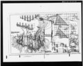 | 4,810 × 3,870 (17.75 MB) | Fæ | GWToolset: Creating mediafile for Fæ. HABS batch upload 26 June 2014 (151:200) |
File usage
The following page uses this file: